
MAPS UPDATED OCT. 16
With San Francisco on lockdown to stop the spread of coronavirus, it’s more challenging than ever for homeless people to find a place to wash up.
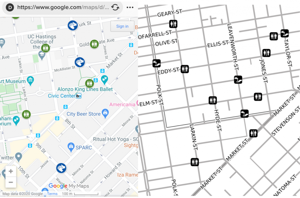
We made a simplified, black-and-white map that shows the city’s central hand-washing stations and pit stops. It can be cranked out from any standard home printer.
If you’re out running essential errands, you could post maps in your neighborhood so that people know where to find these crucial services. This is especially important when fundamental resources like public libraries with restrooms are closed. The hand-washing stations cropped up with COVID-19, but pit stops have been around since 2015. Pit Stops include toilets, sinks, needle disposal and dog waste stations.
Here are the maps we’ve done so far, we continue update them as the Department of Public Works adds new ones:
The data comes from the San Francisco Department of Homelessness and Supportive Housing (HSH) and Data SF. We made them using QGIS, OCHA humanitarian icons with an assist on the inserts from Stamen’s Toner.
The maps were inspired by the community responder maps we made for the San Francisco Fire Department. Cut out the noise, the color, make them printable from home and you have something good to go in an emergency.
The Google map made by the city looks nice online, but is noisy if you’re trying to navigate by mobile phone — and forget about printing it.
Hopefully, San Francisco will be getting more to come into line with United Nations guidelines for emergencies.
The UN standard is 1 bathroom per 50 ppl during emergencies.
There are roughly 5000 people unsheltered on our streets, and many more who are also in need of bathroom access, w most public facilities & coffee shops closed.
So we need at least 100 public bathrooms, likely more.
— Matt Haney (@MattHaneySF) March 26, 2020
Here’s a complete list of the pit stops and hand-washing stations in San Francisco. We’ll be making more maps in the next few days to cover the whole city. San Francisco Public Press has a fantastic rundown of the conditions of them, check it out.
Pit stops
- Myrtle and Larkin streets (JCDecaux) – Daily – 9am to 8pm
Mid-Market
- Hallidie Plaza (JCDecaux) – Daily – 7am to 8pm
- U.N. Plaza (JCDecaux) – Daily – 9am to 8pm
Mission
- 16th and Capp streets – Mon-Fri – 11am to 6pm
- 16th and Mission streets (JCDecaux) – Daily – 9am to 8pm
- 18th and Mission streets – Mon-Fri – 12:30pm to 7:30pm
- 24th and Mission streets (JCDecaux) – Daily – 9am to 8pm
- 23rd St. and Treat Ave. – Open 24 hours
- 344 14th St. – Open 24 hours
- 1661 15th St. – Open 24 hours
- 1645 Bryant St. – Open 24 hours
- 1850 Bryant St. – Open 24 hours
- 220 San Bruno Ave. – Open 24 hours
- Harrison and 26h streets – Open 24 hours
- Cesar Chavez and Potrero Ave. – Open 24 hours
- SFGH, near SE corner of Building 25 – Open 24 hours
- SFGH, near SE corner of Building 80/90 – Open 24 hours
North Beach
- Washington Square at Union St. (JCDecaux) – Daily – 9am to 8pm
Ocean Beach
- Great Highway near Beach Chalet – TEMPORARILY CLOSED
Outer Sunset
- Judah and La Playa streets (Rec Park) – Daily – 9am to 4pm
Richmond
- 18th Ave. and Geary Blvd. – Open 24 hours
- 24th Ave. and Balboa St. – Open 24 hours
- 48th Ave. and Fulton St. – Open 24 hours
SoMa
- 6th and Jessie streets – Open 24 hours
- Victoria Manalo Draves Park (Rec Park) – Mon-Fri – 8am to 4pm; Sat-Sun – 9am to 5pm
- Mission and Seventh streets – Open 24 hours
- Mission and Ninth streets – Open 24 hours
- 148 Sixth St. – Open 24 hours
Tenderloin
- 133 Golden Gate Ave. – Mon-Fri – 2pm to 9pm; Sat – 9am to 4pm
- 101 Hyde St. – Mon-Fri – 1:30pm to 8:30pm; Sat – 9:30am to 4:30pm
- Eddy St. and Jones St. (JCDecaux) – Open 24 hours
- 388 Ellis St. – Mon-Fri – 9am – 4pm; Saturday 9am to 4pm
- Eddy St. and Larkin St. – Mon-Sat – 9:30am – 4:30pm
- Willow and Franklin streets – Open 24 hours
- Leavenworth and Turk streets – Open 24 hours
- O’Farrell and Taylor streets – Open 24 hours
- 116 Turk St. – Open 24 hours
Hand-washing stations
- Willow St. and Polk St.
- Hemlock St. and Van Ness Ave.
- 527 5th St.
- UN Plaza: Leavenworth St. and McAllister St.
- Ashbury St. and Haight St.
- Barneveld Ave. and Loomis St.
- Florida St. and 17th St.
- 456 Winston Dr.
- 3565 16th St.
- Market St. and Steuart St.
- Ellis St. and Taylor St.
- Turk St. and Leavenworth St.
- Mission St. and 9th St.
- Selby St. and Evans Ave.
- 1550 Bryant St.
- Jackson St. and Powell St.
- Folsom St. and 23rd St.
- 1634 Armstrong Ave.
- Thomas Ave. and Hawes St.
- Carroll Ave. and Ingalls St.
Nicole Martinelli is a San Francisco native who started Resiliency Maps so she would know where to go in case of an earthquake. She’s been a member of the Neighborhood Emergency Response Team (NERT) since 2010 and is the co-coordinator for the SOMA neighborhood. Contact her here.
One thought on “Stopping COVID-19 in San Francisco: Here’s a simple, printable map of hand-washing stations and pit stops”