

If Resiliency Maps has one big idea, it’s to get you looking differently at your surroundings.
Recently, I gave a lightning talk at FOSDEM 2023 about getting your “emergency eyes” laser focused.
It was my first in-person event in three years and the title was supposed to sound sort of exciting — to disguise the fact that this can be really tedious mapping. That said, it just might be the most useful mapping you do for the place you live. The boring bits (translation, tagging) are balanced by the fact that if you do it right, there’s equal parts diplomacy and activism, too.
Most of the 100 or so people in the room already contributed to OpenStreetMap, but almost none were active in Humanitarian OpenStreetMap or emergency responders, so there was plenty to home in on.
I got started with OSM through HOT – it was amazing to armchair map to help folks in Nepal right after an earthquake. (You can get started now to help out in Turkey and Syria, too.) Since I’m also volunteer emergency responder, it occurred to me that we could do more with OSM at home so about five years ago, I started RM in my hometown of San Francisco. Our “classic” emergency is earthquakes, the last major one was over 30 years ago but it’s predicted that there will be another of at least 6.7 magnitude ( 99.7% ), in the next 30 but guess what?
In half a decade, we haven’t had even a really good shake.
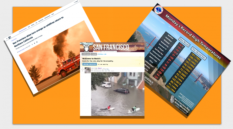
The emergencies keep coming, though, just new kinds outside the usual prep. Starting with the smoky orange skies (nicknamed “Bladerunner” effect) in 2018 and 2020 from wildfires. The smoke and air quality were so bad that residents were advised to wear masks indoors, since typically buildings here don’t have sophisticated HVAC systems.
Part of our emergency kit contained respirator masks — sold then only in huge quantities — and I remember splitting open the towering pack, trying to wear one for more than a few hours at a time, thinking “no way.” Then the covid pandemic flipped common sense prep guidelines, there have also been record-breaking heat waves and, most recently, bomb cyclone flooding in January 2023. The upshot: we all need to prepare for different types of emergencies that happen more frequently.
Case study: Florence, Italy
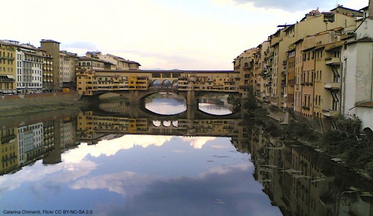
Florence is a good example of how this plays out in Europe. I’ve lived there (and organized a mapathon pre-pandemic.) The capital of Tuscany has long contended with the Arno river running through it. Since first known flood in 1177, the river has breached its banks and inundated Florence 56 times. Water scars run deep around the city, in the form of flood markers or the Palazzo Capponi alle Rovinate and the church of Santa Lucia delle Rovinate – both named after families ruined by floods.
This is your translation and data entry case – using a wealthy, famous city with a lot of smart people working there – they’re even using OSM as a base map for an emergency app the government produced. When it comes to emergencies, though, there doesn’t need to be an app for that. Or not always, at least. (Think about connectivity, electricity and what device you might have to hand during an emergency.) You also have to know the app exists, find it, download it, use it. Researching the talk, I couldn’t remember: Was it called informed citizen? Or informed citizens? Or something else? (It’s cittadino informato.) The info is siloed here, only in two languages — Italian and French — and doesn’t reflect population needs or account for massive tourist waves.
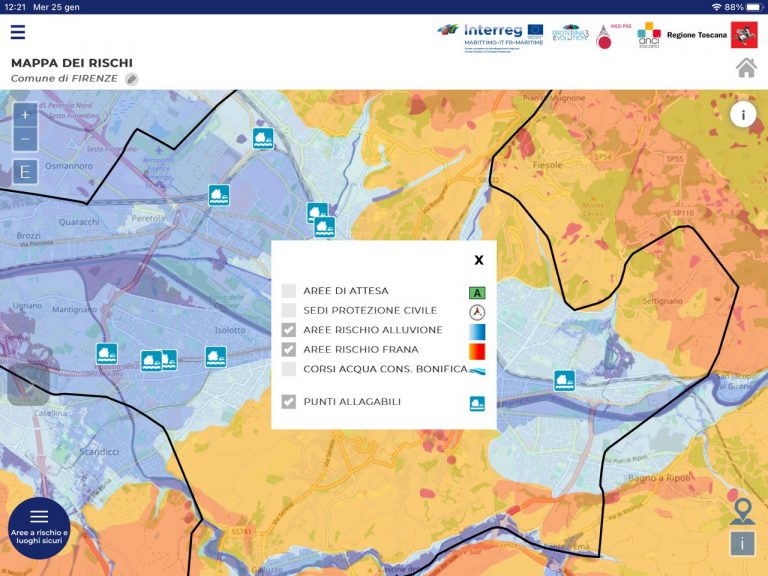
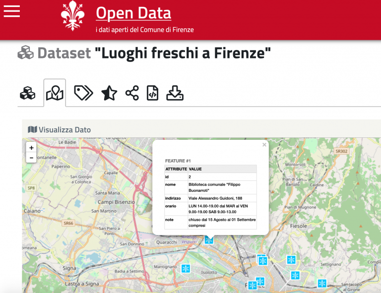
The darker areas are prone to flooding, orange parts to mudslides – so pretty much all of Florence is affected. The points are extra flood-prone danger spots. This info is trapped in an app, though.

One of the advantages of mapping in Europe: the bounty of street-level imagery. You could check these points with Mapillary from the OSM RapiD editor to discover that one of them is an underpass prone to flooding (good to know!) and add it to OSM. If you’re trying to get home in a storm, you need this info in an app with navigation (like OSMAnd, for example) not a static one.
Adventures in open data
Typically, a city like Florence has an open data program. This example is for the second “emergency classic:” earthquakes. This shows you where the emergency shelters are.
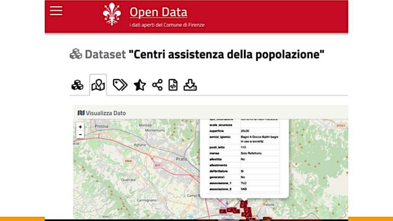
It’s likely you’ll be more connecting dots than anything else: many towns have robust volunteer communities – in Florence, it dates back to medieval times with the Misericordia. Above is a school gym assigned to two volunteer groups, tells down to the number of beds, showers and whether they have a ham radio, tested it etc. (We have nowhere near this kind of public info in San Francisco it’s impressive.) But. It’s not on OSM. So it’s up to you to figure out the right tags and add them. A lot of what you see on Italy’s lively OSM Telegram channel is about “How should this be tagged?” Osm runs on British English – so as an American, I’m often at a loss, too. Most of the time an equivalent will be there, if you look or ask around. It’s worth remembering that if you some features specific to your country, you can lobby the community to add them. We’ve done this for RM – for call boxes and soft-story buildings.
New emergency: Heat waves
This is your activism/ diplomacy case. Florence has also been scorched by heat waves and record temps -there’s a robust public alert system for these. Part of the advice is to get out of the heat in the hottest hours of the day, so there’s a dataset of what’s now called in US “cooling centers” – a public place you can hang out in just for the air conditioning, often libraries. The trouble? There isn’t a single one open the whole month of August, when the entire country heads to the beach. Except the elderly and anyone who can’t afford it. So you need a Plan B. Also, in Florence May and June have a handful of local and national holidays, so it’s not just August.
There’s a lot of work to do: As of this writing, there are only a handful of places tagged with AC in OSM – and even if you know Italians don’t love AC, this can’t be right.
Currently, none of the libraries from the open data set are tagged, so that’s easy to do. Then you can start thinking about what other public places have it – Florence has a large new university campus on the outskirts that has AC and it’s basically empty in august. What about businesses? You might as well tag them – not out of the question that if you went to them saying – no one’s using your business center or conference room in August, they might let your group bring people.
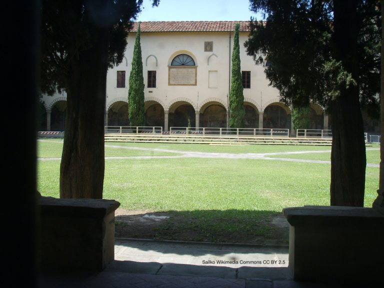
Italy is also full of churches – cool inside, but maybe harder to get permission, custodians etc. What about courtyards? There are at least 12 cloisters in Florence, by design they are protected, shady, and cool. Below is the Chiostro Grande in Santa Maria Novella – reopened to the public in 2012. Again, your local knowledge makes a difference. Tag everything but don’t pitch the mayor or emergency services the other courtyard in the complex with the famous Paolo Uccello frescoes. One of the cooling center libraries, the former convent Le Oblate, has two courtyards with multiple stories and could serve as a backup for August.
The courtyard in Santa Maria Novella is mapped down to the tree – but not yet tagged as a courtyard. It’s the kind of feature that as a resident you know is there, so does everyone, but they’re not looking it in these terms. This is the activism case because once you’ve got detailed maps, you can pitch the business associations, the mayor etc.
This is also where paper comes in – because what might be most useful are neighborhood maps pasted around – here’s the closest cooling center near you, open during these hours. We’ve done a few paper maps for this reason in San Francisco – because the important bit is having enough detail in the database that you can print it at a neighborhood level and get info to people where/when they need it. To get OSM maps on paper, we’ve used Print Maps and MyOSMatic.
There were two main questions from the folks participating at FOSDEM: How do I find a group in my area? First stop, the OSM Wiki. And the second question was whether we’d reached out to StreetComplete to see if they might add features like these. We should — but in the U.S. since the app is only available on Android, excluding about half of mobile phone users.
One thought on “How to sharpen your emergency eyes with OpenStreetMap ”