
This guide digs into the details of running a two-hour mapathon. It draws on the experience of Resiliency Map’s first training with about 20 participants from San Francisco’s Neighborhood Emergency Response Team (NERT.)
This time we focused on Field Papers, a great way to get a group mapping with OpenStreetMap without a lot of computer time. More on FP here. If you’re just getting started and looking for info on how to choose a venue and promote your event, try this from Learn OSM guide or this on hosting one from Missing Maps.
Overview of the two-hour session
- @15 minute intro to Resiliency Maps, OSM
- 10 minutes on Field Papers, reviewing data targets, the key for targets and team composition
- 5-10 minutes questions
- @45 minutes mapping in the field
- 10-15 minute demo on how Field Papers works and uploading sample edits
- 10-15 wrap up for questions, getting emails, feedback
Times are approximate, we had such a good time chatting to people that we ran about 15 minutes over. There was some expected futzing with the projector setup for the presentation so we started slightly late.
Set expectations
The session was only open to NERTS and presumed no mapping experience. NERTS are trained to have a sharp eye for assets and hazards in their surroundings, the data targets (see below) reflect that.
The description of the workshop from the Eventbrite page:
This two-hour workshop will show you how to start editing OpenStreetMap to add or verify features relevant to NERT. Resiliency maps store information about assets, resources and hazards in a given area. They can be printed and housed offline – a crucial advantage when electricity and connectivity may down or disrupted for days. OpenStreetMap is a collaborative project to create a free editable map of the world, often called the Wikipedia of maps.
Requirements: No previous mapping experience necessary. We’ll be walking outdoors for a portion of the workshop, so layer accordingly.
Optional: Create a free OpenStreetMap account and bring the credentials with you. Time permitting, we’ll upload edits to personal accounts.
That said, about five people showed up with laptops and OSM logins; two or three were already familiar with OSM and had contributed to it. It’s worth repeating ahead of the event what devices/knowledge folks are expected to bring if you have control over the invite process. (We were fortunate to have the San Francisco Fire Department supporting the effort, providing the venue and EventBrite.)
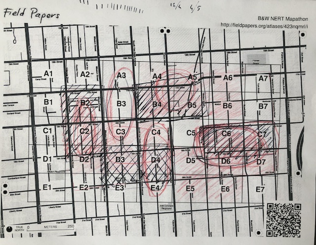
Nail your data targets
Given the tight data collection time frame (45 minutes – due to overall time constraints and unpredictable winter weather) the mappers had just four types of targets:
- Soft story buildings
- Hazards (anything with a hazard diamond – car repair, paint stores, etc.)
- Restaurants/bars (also hazards due to commercial kitchens, large quantities of alcohol)
- Shelters (community centers, playgrounds)
Extra credit
- Based on a trial run of the area, some we knew they might come across:
- Police/fire call boxes
- Construction sites
- Cisterns
Write-ins (on a limited basis!) There were a fair number masonry buildings, warehouses, etc. These are all building tags in OSM that would be useful for a Resiliency Map as well as damage assessment.
Along with the map squares, teams had a brief key for the targets (example: soft story=SY) that reminded them to note the target address for accuracy.
#NERT training day also featuring a mapathon. Big thanks to @resiliencymaps for #Volunteering to teach us #sfready #earthquake #preplanning #preparedness #teamwork #situationalawareness #civicduty #CERT #SanFrancisco pic.twitter.com/de2F2N2XOx
— SFFD NERT (@SFFDNERT) December 15, 2018
Pick teams
After running a two-person test in the area, we decided larger groups might be more productive. We broke them down like this:
- Captain/scribe (person with good handwriting!)
- Timekeeper/safety (when you’re on that clipboard, stoplights and random stuff on the sidewalk are not on your radar.)
- Scout(s) Fast walker who goes ahead, decides direction. Some of these blocks had a lot of targets, others had little.
Who’s running this thing, anyway?
Three of us ran the workshop. One person gave the overview presentation and basic training. During the presentation, the field coordinator divvied up maps in a checkerboard pattern (so mappers wouldn’t overlap) and prepped the clipboards with map squares and a key. Once the teams formed, we answered some final questions and they were off!
The third person, the OSM editor, used the field time to set up and when the first teams came back, photographed the maps and started uploading edits. The OSM editor had a cheat sheet with preset tags based on the data targets, write-in options and San Francisco’s Department of Building Inspection’s soft story list for verification. The other two people also had laptops and this material, too.
As the teams trickled in, the other two fielded questions, collected clipboards. Once the teams were all back, the OSM editor walked the participants through a set of edits from Field Papers to OSM upload.
Overall, the division of tasks worked. Next time it’d be wise to recruit one of the participants to take pictures for blog posts/social media. That was the one thing we were too busy for!
Uploading the edits
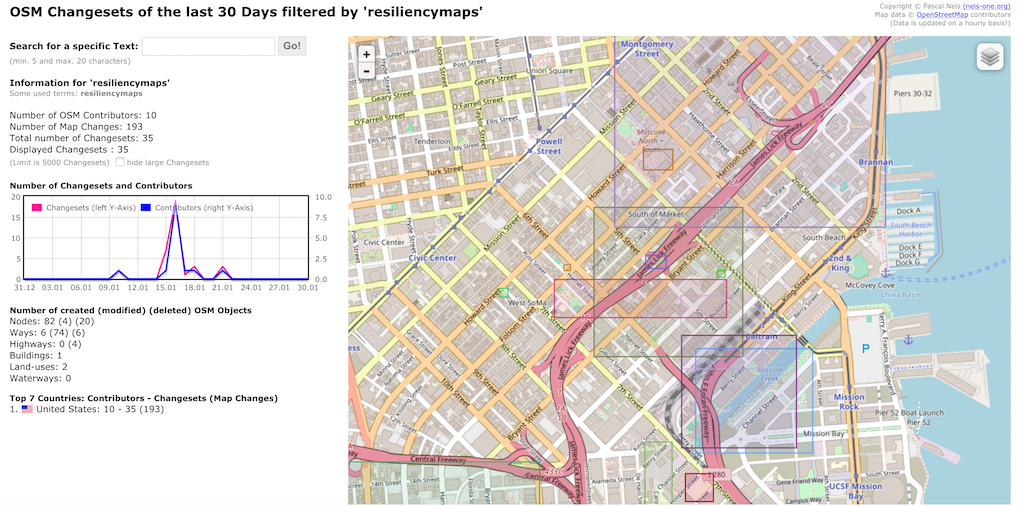
As expected, we uploaded only a sample of edits during the workshop. We split up the remaining Field Papers, decided on a hashtag for the changesets (#NERTmapathon) so we could both track the edits and then contact participants and show them the complete output. There are a number of tools you can use to visualize your changesets, check out the filter from the indefatigable Pascal Neis (screenshot above), OSMCha and Whodidit.
One thought on “How to run an OpenStreetMap mapathon using Field Papers”